Picture Day Friday

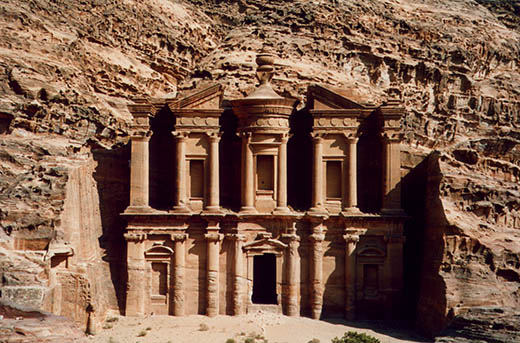
Al Deir at Petra in Jordan is one of the places I want to visit before I die.
Hidden amidst nearly impenetrable mountains to the east of the valley connecting the Gulf of Aqaba and the Dead Sea stands the ancient city of Petra. One of the world’s most visually stunning archaeological sites, Petra (meaning ‘the rock’ in Greek) is an abandoned necropolis of temples and tombs cut into towering cliffs of red, pink, and orange sandstone.
Located in a remote gorge, northwest of the center of Petra, Al Deir is the largest and most visually stunning of all the structures in Petra. Carved entirely out of the red sandstone of a mountain wall, the temple is 50 meters wide by 45 meters tall and has an 8-meter tall entrance door. Inside the single empty chamber (12.5 by 10 meters), the walls are plain and unadorned except for a niche in the back wall with a block of stone representing the deity Dushara.
The chief deities of the Nabataeans were Dushara, Al-Uzza and Allat. The name Dushara means ‘He of the Shara’, referring to the Sharra Mountains on the northern border of Petra. Like the Hebrew god, Jehovah, Dushara was symbolized by an obelisk or standing block of stone (and this indicates influences from archaic Sumerian, Egyptian and megalithic cultures) and his symbolic animal was the bull.
Primarily known as a commercial and ceremonial center of the Nabataean culture during the centuries before and after the time of Christ, this region of Petra was inhabited in far greater antiquity. Archaeological excavations have revealed a rock shelter of the Upper Paleolithic period, dating to around 10,000 BC, and a Neolithic village from the 7th millennium BC. While evidence of habitation during the Chalcolithic and Bronze ages has not yet been found, the region of Petra was again occupied in the early Iron Age, around 1200 BC, by the Edomite culture of the Old Testament (Edom, meaning 'red', is the Biblical name for this region of the Middle East).
Petra’s prominence also derives from its proximity to ancient caravan routes, its easily defended location, stable water resources and proximity to rich agricultural and grazing lands. The Nabataean capital was strategically situated only twenty kilometers from the crossroads of two vital trade routes; one linking the Persian Gulf (and thereby the silks and spices of India and China) with the Mediterranean Sea (and the empires of the Greeks and Romans), the other connecting Syria with the Red Sea.
The above text is taken from Sacred Sites. For an in-depth essay on the history of Petra and it's modern-day discovery GO HERE!

0 comments:
Post a Comment